I’m posting four final blogs of Nepal:
- Hike one, Annapurna Circuit (the blog you are reading)
- Hike two, Annapurna Sanctuary
- Resting in Pokhara
- Riepe Village
I was in Nepal for just over two months, Sept/Oct/Nov, 2018. I spent two weeks in Kathmandu and the rest of the time in Pokhara , hiking around the Annapurna Mountains, and a brief visit to Riepe Village.
The Annapurna Circuit is a trek within the Annapurna Mountain range of central Nepal. The total length of the route varies between 100-145 miles, depending on how far one rides along the trek before starting to hike, and where you end. The Chinese are pushing roads well into the mountains on what were trekking routes in order to build hydro-plants along the rivers. Depending on where you begin, there is a lot of road hiking. These roads range from what we would call a rough dirt road to nearly impassible ruts which run through rivers, along ledges, and through landslides. And yet, buses run in and out of the remotes town a few times a day.
I don’t know how many miles we hiked. We began in Besi Sahar, having taken a taxi from Pokhara, and we hiked to Jomsom in 12 days. In Jomsom I sent my porter and guide back to Porkhara while I visited a hot spring along the route for two days, before taking a bus back to Pokhara.
The Circuit trek crosses two different river valleys and encircles the Annapurna Massif. The path reaches its highest point at Thorung La pass (5416m/17769 ft), touching the edge of the Tibetan plateau. Most hikers go counter-clockwise—this is what I did—which allows for slower altitude gain and more time to acclimate, making the hike over the Thorong La pass easier.
The map below shows part of the areas I hiked. The red line is part of my first hike, Annapurna Circuit, the red circle is the destination of my second hike. If you think of the Annapurna range of mountains as a horse shoe (very roughly), the Annapurna Circuit Hike went around the sides and top on the outside of the horse shoe while the 2nd hike, the Annapurna Sanctuary, also called Annapurna Base Camp (ABC), went up the middle of the horse shoe.
On the Circuit, the first hike, almost by mistake, I ended up with both a guide and a porter. I had the guide because I was told I needed one—this is untrue as the trail is well marked and passable English is spoken everywhere I went—I had the porter because after carrying my too-heavy pack (I know, I know, it is hard to understand how I don’t get this yet
) for three days it was clear to me that I was not going to make it unless I was without a pack.
The Annapurna Circuit hike was first and it took 14 days. After this hike I went back to Pokhara for six days and then did the ABC hike, that took 8 day: 6 days in, 2 days to hike out. The ABC hike was the hardest hike I have ever done. In part this may be because I had not fully recovered from the Circuit hike, but it is also because it is a brutal hike and I was carrying my own pack, although significantly lightened. I did not use a guide or a porter on the second hike and of course I was in better condition after the first hike. Day after day the ABC trail drops directly into deep valleys, from which you must then climb out.
And stone steps! So many they blur. And in most cases the builders did not know what a riser was, varying them from 1” to 24” randomly. On the other hand, there were sections of stairs and walls and buildings that were carefully built with great skill and what must have been a herculean effort to mine, shape, transport, and finally to build the structures.
The hardest thing to convey in photographs is scale. The mountains that surround us are massive--not massive in the sense of "its massive dude", but massive in that they take your breath away--and the scale does not translate well, except in a few cases.
You are welcomed to share these blogs with anyone.
 |
| The wind flowing snow into the sky. |
 |
While in Kathmandu I had a wonderful guide, Amit, showing me the sites. Amit photographs his culture
and this photo is one of his. I'm don't know where it was taken. |
 |
Two friends I hiked with on part of the Annapurna Circuit, Yakut & Angel. Yakut is Turkish and a
funny kind spirit who hikes a lot and in many places. Angel is from Spain and a crazy
strong hiker. A couple of times he hiked in one day what took us two. This is taken at the base camp.
Yakut sent me this and the next photo when I realized I did not have any photos of Angel
. |
 |
| I wonder how long this bridge has been in service? |
 |
This landslide happened a couple of years ago. There is a house near the top of the
mountain, a few hundred feet from the left side of the slide, it is still lived in. |
 |
| Notice the town just to the right. |
 |
There were so many water falls, seemingly
around every corner, that I stopped photographing them. |

 |
| This is a road cut into the mountain side. |
 |
| This is Raju my guide at the entrance to the town in the next two photographs. |
 |
| Leaving a town. |
 |
| Someone spent some time commemorating their 2018 trek in the bed of the river. |
 |
| A hiking trail cut into a sheer rock face. |
 |
| A road and the hiking trail for several miles. |
 |
This is the road, over which drive loaded trucks and buses and the trail, the "bridge"
is nothing more than logs laid in various direction with dirt over them. I'm assuming
at there was at least one other culvert that got washed away. |
 |
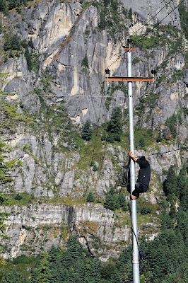
These guys were working on electrical poles along
the road. I did not see a truck or ladders to
get them up the poles. I asked the supervisor how they
got up there and he laughed and made a noise
like a monkey and said, "they climb." The
guy on the left has bear feet, the guy above
has sneakers on. |
 |
I saw perhaps forty piles of stones like this one on my two hikes, and
what amazed me was the work that went into mining, cutting, moving, and
stacking tons of rock, entirely by hand. They are used on homes, walls, and roads. |
 |
They are mining the stone from this hillside.
The men wear flip flops and are bare handed. |
 |
| A road cut into a sheer stone cliff face. |
 |
It is difficult to convey how massive this stone face is. I'm guessing the trees in the distance are
1.5 to 2 miles away while the top of this mountain is 2000' and more above our heads. |

 |
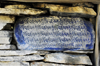
I'm unsure of what these are called, but in various sizes and ages (this one
is extremely old, some are newer) they are along the roads and paths. The newer
ones have pray wheels of various sizes in them and the passerby's spin
the pray wheels while saying a prayer. Like this one many have stones carved with
prays in place of the pray wheels, which have worn out. Below are photos
of the pray stones that we found along the way. |

 |
I love this stone work. First for the
quality of laying and the hand-hewn beams laid in every
six or eight feet to stabilize the stone and tie
them together and then for the sheer size of the building. |
 |
The vertical log with the scoops cut out is a ladder, dropped down to allow visitors up to
the living quarters on the second floor, animals and grain or kept on the ground floor. |
 |
| I don't know what this is, but there were several of them leaning against this building and I liked the shape. |
 |
This is an old Buddhist Stupa, (1000 years?) they have built
the roof to slow deterioration. |
 |
| Our trail is the upper one running around the shoulder of the closest mountain. |
 |
We scared these mountain goats away from the river we're walking past, they scrambled
to high ground to wait for us to pass. |
 |
This is the roof of a very large and old,
perhaps 300' long x 30' high, building in which animals
and people still live. The people on the roof are enjoying the sun and the scenery.
|
 |
| I was told that this house is over two thousand years old. |
 |
| One of the more rustic lodges along the trail. |
 |
This women is coming out from having spun the
huge pray wheel several times. |
 |
We will walk along the road/path you can see in the trees to the right, around the foot of the
mountain and up into the town show in the preceding photos. |
 |
| YAKS! |
 |
| A Buddhist Monastery. |
 |
| The same Monastery as we approach the town. |
 |
Entrance to the town at the end of the road,
from here on there is only a foot path. |
 |
| Digging potatoes |
 |
Mike and I hiked out from the town and then back, this time along the
base of the mountain, through a field populated by yaks. Mike and
Mick (no photos of Mick) were Aussies I hiked with and met in
various places along the way. |
 |
The stream is running down the stone steps of the trail.
|
 |
This man milks 50 (I think that is what he said)
Yaks every morning and makes Yak cheese. This is
his daughter and grandson. |
 |
On the ground floor of their house, they cook the
yak milk (you can barely see an ember from
the fire in the blackness). |
 |
| YAKS! |
 |
This is a huge impressive stone building. They are homes with stables and storage
on the first floors. I would have liked to know when they were built. |
 |
| There were a lot of folks on the trail. |
 |
| Heading toward base camp and then to the pass, you can see tiny, ant like figures further up the trail. |
 |
| My guide Raju on the right and Yakut's porter. |
 |
| There are horses grazing in this photo. |
 |
| And horses heading to the grazing area in this one. |
 |
| A long hard up. |
 |
| This made me laugh. |
 |
| We found fresh apples! And they were GREAT. |
 |
| An apple orchard. |
 |
The worn tiers you see at the bottom of the photograph, this side of the river bed, was the garden area
for a village that once existed perhaps 2000 years ago (just to the left of this photograph). Only the outline of houses remain. |
 |
Over looking this valley, including the two following images, was the first time that
I felt we were away from the tourist route of the trek. It is a breath taking sight.
I wanted to spend time in each of these towns and now I wonder why I did not. |

 |
This and the following three photos are of the road going back to Pokhara.
We are riding in a bus. I was told that about once a month a bus goes off the
side of some road and lands a thousand feet below in the river.
Our driver was very good. |


No comments:
Post a Comment